Nong Yai Park
Location: https://maps.app.goo.gl/8mbeLsKo8zmJ1v5S7
The main flood management system is a diversion canal running from the Tha Taphap river in the west of the park to the Phanang Tak river in the east, which is near the sea. In times of heavy rain, water can be diverted through the canal preventing/reducing any flooding in the area around Chumphon town.
Following the pathway along the western bank you will come to the area where they feed the Javan rusa deer. You can buy bananas to feed the deer.
Past the feeding area you will find a suspension bridge that will take you back onto the road.
One year our family entered the Fun Run which is very popular.
Nong Yai Park is 8Km north of Chumphon town. Take road No. 1107 out of town and the entrance to the park is on the right 2km after the large white Government buildings.
The park came about following the devastation caused by Typhoon Gay back in November 1989. 529 people were killed, 160,000 became homeless, with 7,130 km2 of farm land destroyed.
Under Royal Initiative a system of flood control measures were implemented. The story of the Kings visit is depicted on a series of stones found on a mound in the centre of the park.
The main flood management system is a diversion canal running from the Tha Taphap river in the west of the park to the Phanang Tak river in the east, which is near the sea. In times of heavy rain, water can be diverted through the canal preventing/reducing any flooding in the area around Chumphon town.
Good roads boarder the canal and being flat are popular with cyclists.
Either side of the canal can be found large storm water management lakes (retention basins).
There is a nice walkway around the lake to the north of the canal.
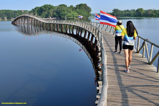
As the car park is near the Learning Center we did the walk around the lake in reverse order to the numbering shown above. First is a long wooden bridge.
The footbridge takes you across the lake to an island.
The island is covered in trees providing nice shade from the sun and a concreted path leads you all the way around.
On the western side of the island is another bridge where you can cross to the western bank of the lake.The island is covered in trees providing nice shade from the sun and a concreted path leads you all the way around.
Past the feeding area you will find a suspension bridge that will take you back onto the road.
The lake on the southern side of the canal is smaller but is popular for events, such as long boat racing.
You can also walk all the way round this lake on a made path, or use the cycle path at its side. Two observation platforms allow you to get a good view of the area. Depending on which day you go there are places to eat and rent boats.
In the center of this lake is this large monkey statue.
After heavy rains in November 2018 most of the park was under water with only the top of the Nong Yai Wooden Bridge showing. Did not hear of any major flooding in the Chumphon town area so guess the flood management system worked.
The Park is often the venue for Fairs and Events.


A wonderful place to visit and take your camera :)
ReplyDelete